 Google Maps Now Shows Directions for Metro and Metrobus
✉️ Want to forward this article? Click here.
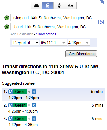
Greater Greater Washington reports that Google Maps has now added Metro and Metrobus to the available travel methods you can use to figure out directions from Point A to Point B. GGW also notes that there will be a joint announcement from WMATA and Google tomorrow, and fingers are crossed that the news will be a full integration of WMATA data into Google Maps. That integration would make trip planning on Metro and Metrobus possible using the most popular web-based mapping application available (and UrbanTurf’s own favorite).
It would also mean that most of the entire DC metropolitan area’s transit services are finally incorporated into Google Maps; the Circulator, Ride On, DASH, Fairfax CUE, MTA, and MARC are already there. Which raises the question why WMATA, the regional heavyweight, is Johnny-come-lately. GGW has been tracking the process for the last couple years, and indications are that the hold-up has been at least partly due to Google and WMATA lawyers hammering out details of the arrangement.
Watch for an update tomorrow after the official announcement has been made.
See also:
See other articles related to: google, google maps, metro, metrobus, wmata
This article originally published at https://dc.urbanturf.com/articles/blog/google_maps_now_shows_directions_for_metro_and_metrobus/3476.


UrbanTurf Listings showcases the DC metro area's best properties available for sale.

Most Popular... This Week • Last 30 Days • Ever

UrbanTurf is re-running its primer on property taxes which outlines a few things that... read »

The wait for Eataly in the DC area has been a long one.... read »

The Arlington County Board signed off on a pair of transformative residential project... read »

The plan to add a shade structure along the Cleveland Park commercial corridor has re... read »

DOGE doesn't seem dead yet; Monument buys Inn of Rosslyn; and Costco gas stations are... read »


DC Real Estate Guides
Short guides to navigating the DC-area real estate market
We've collected all our helpful guides for buying, selling and renting in and around Washington, DC in one place. Start browsing below!
First-Timer Primers
Intro guides for first-time home buyers
Unique Spaces
Awesome and unusual real estate from across the DC Metro