What's Hot: 142-Unit Development At Inn of Rosslyn Site Moves Forward | Mortgage Rates Inch Closer To 7%
 The Full DC Streetcar Routes Explained
✉️ Want to forward this article? Click here.
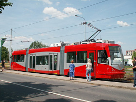
Most DC residents are aware of the new streetcar line being constructed along Benning Road and H Street, but many people probably don’t realize just how extensive the fully built-out streetcar network will be. The H Street-Benning line is just the first step in a grand plan to outfit the entire District with a new mode of public transportation. Thirty-seven miles of proposed lines will connect the city in ways never imagined, and, if realized, will likely spur the development of neighborhoods and surrounding regions that have been underdeveloped for decades. Understanding the plan is important for forward-looking home buyers who want to be strategic about buying in a neighborhood that is targeted for a streetcar line.
Intended for communities in DC that are not adequately served by the existing Metro infrastructure, the streetcars will help to connect emerging neighborhoods, and allow for a more efficient, effective, and (hopefully) economical alternative to the maze of often confusing and unreliable bus routes running through the city. The streetcars themselves were made in the Czech Republic and introduced to the public this year. With the initial line planned for Minnesota Ave to Union Station, many of the residents and businesses living along the line have a big stake in the success of the project. When DC City Council took funds for the project out for next year’s budget, uproars from affected residents were heard, and the funds were quickly restored.
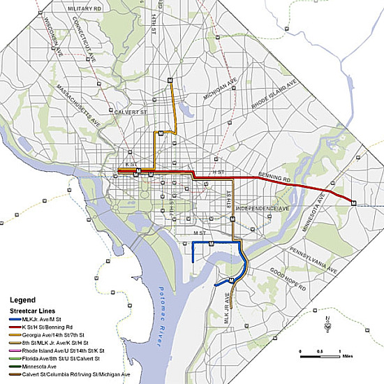
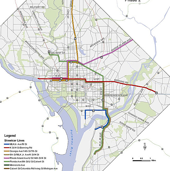
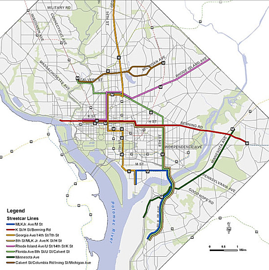
A total of eight streetcar lines are currently planned, with construction to take place in three separate phases, outlined below. It should be noted that the build-out will not occur according to a strict schedule. The plan will almost surely change over time, and the build-out of additional lines will likely depend very much on the success of the line currently under construction.
According to DDOT, the first phase of the project will see a streetcar line extending beyond its current terminus of Union Station all the way to downtown DC, in the vicinity of K Street NW. A second line in Phase 1 will connect MLK Jr. Avenue in Southeast with M Street SW in an apparent attempt to adjoin the burgeoning Nationals Stadium area with Anacostia just across the river. Additionally, the third and fourth lines in Phase 1 will connect both Georgia Avenue NW and MLK Jr. Avenue with downtown.
Phase 2 will double down on an already ambitious plan of four lines by extending one of those lines and adding an additional two. The Georgia Avenue line will be extended significantly to the Tacoma Park Metro area. One of the new lines from Phase 2 will connect Rhode Island Avenue all the way from Eastern Avenue through downtown DC. Another will swerve its way from the southern portion of MLK Jr. Avenue SE all the way to Calvert Street NW. This line will go north along 8th Street SE until hitting Florida Avenue and crossing over to Northwest at the U Street area.
Phase 3 plans for a Minnesota Avenue line that extends from the Metro station south through Anacostia tracking the path of the Anacostia River. In addition, a line from Calvert Street NW to Catholic University tracking Colombia Road, Irving Street and Michigan Avenue would assist with east-west traffic in the city.
The total of eight streetcar lines presents a number of engineering, political, financial, and logistical challenges for the city. It also poses one of the greatest opportunities to address the growing population and nearly maxed-out Metro system, promotion of development in underutilized neighborhoods, as well as the chance to create one of the foremost above-ground American public transportation systems.
See other articles related to: dc streetcars, dclofts, streetcars
This article originally published at https://dc.urbanturf.com/articles/blog/the_full_dc_streetcar_routes_explained/2236.
Most Popular... This Week • Last 30 Days • Ever
Buffett called the five-bedroom listing home when his father, Howard Buffett, was ser... read »

Estate taxes, also known as inheritance taxes or death duties, are taxes imposed on t... read »
The application may signal movement on the massive mixed-use project.... read »
Penzance has unveiled its striking new plans for Rosslyn.... read »
A new report finds that the current housing market is split into two groups.... read »
- The Oracle of Spring Valley: Warren Buffett's Childhood Home in DC Hits the Market
- What Are Estate Taxes and How Do They Work?
- Raze Application Filed For Site Of 900-Unit Development, Food Hall Along Anacostia River
- Three Buildings, 862 Units: The New Plans For Rosslyn's Skyline
- The Two Housing Markets
DC Real Estate Guides
Short guides to navigating the DC-area real estate market
We've collected all our helpful guides for buying, selling and renting in and around Washington, DC in one place. Start browsing below!
First-Timer Primers
Intro guides for first-time home buyers
Unique Spaces
Awesome and unusual real estate from across the DC Metro
