 When Rent Was $25 a Month and Georgetown Was the Affordable Place to Live in DC
✉️ Want to forward this article? Click here.
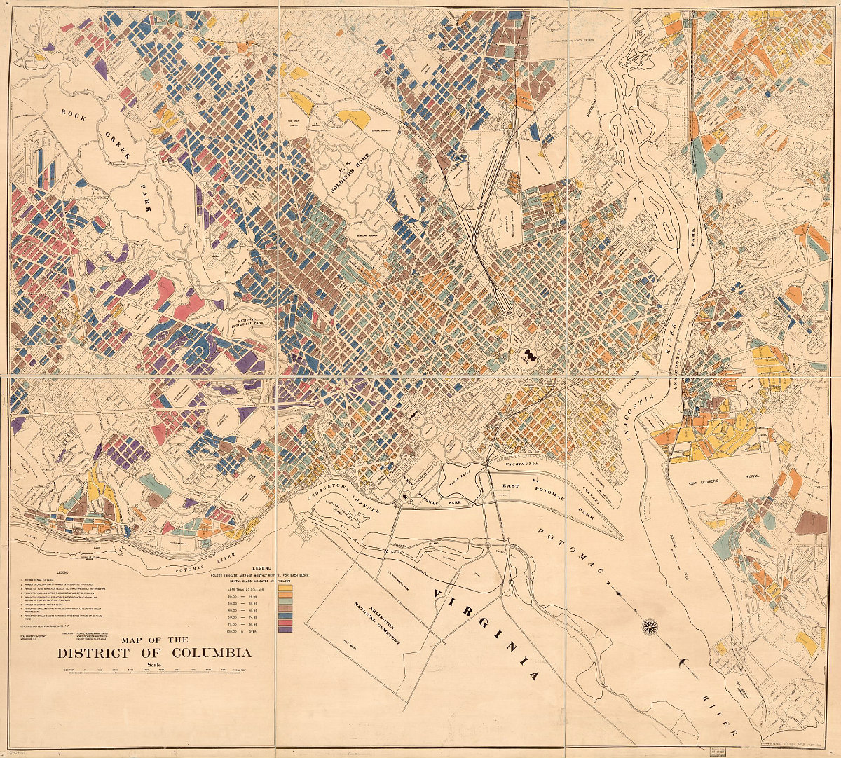
It's hard to imagine a time when expensive rents in DC came in at about $60 a month and the banks along the Potomac River in Georgetown were some of the more affordable places to live in the city.
One of the many maps on the Library of Congress' Online Catalog highlights this era, displaying the average rental rates recorded in the District in 1937.
story continues below
loading...story continues above
For some context, the country was still in the midst of the Great Depression, the average rent nationally was $26 per month, and DC had a population of 616,000. Here are some interesting tidbits UrbanTurf found on the map:
- Much of the "affordable" housing in the city was concentrated along the banks of the C & O Canal and Water Street in Georgetown, with rents on the block closest to the river averaging under $20/month ($356 in 2018 dollars).
- Other areas which were much more affordable in 1937 than they are now include the blocks which used to surround Deal Middle School between Chesapeake and Fessenden Streets NW, and the entire area southwest of Independence and New Jersey Avenues SE. Average rental rates-per-block in these locales were split almost evenly between those under $20/month and those between $20-29.99 ($534 in 2018 dollars). The blocks between Deal, Wilson High School and Wisconsin Avenue NW had average rents of $30-39.99 ($713 in 2018 dollars).
- The entirety of Park View southwest of Otis and Park Places, as well as straddling Sherman Avenue up to Barry Place NW, had average rental rates of $30-49.99 ($891 in 2018 dollars). Rents in Columbia Heights were in the $40-49.99 range with some blocks averaging $50-59.99 ($1,068 in 2018 dollars), while rents edging Rock Creek Park in Mount Pleasant averaged $60-69.99 ($1,247 in 2018 dollars).
- Units on the blocks immediately north and east of Mount Olivet Cemetery in Northeast rented for an average of $49.99-74.99 ($1,336 in 2018 dollars). This was also the case for units straddling North Capitol Street NE/NW between Michigan and Rhode Island Avenues, as well as those straddling Rhode Island Avenue between 10th and 13th Streets NE.
- Within a two-block radius of Logan Circle, the rental rates were relatively diverse. Roughly 11 blocks had average rents of $30-39.99, five had average rents of $20-29.99, four had average rents of $40-49.99, and three had average rents of $50-74.99.
Readers, did you notice anything interesting about the average rent on your block in 1937?
See other articles related to: maps, rental rates in dc, renting in dc
This article originally published at https://dc.urbanturf.com/articles/blog/a-depressing-look-at-depression-era-rents-in-dc/14910.


UrbanTurf Listings showcases the DC metro area's best properties available for sale.
Most Popular... This Week • Last 30 Days • Ever

UrbanTurf is re-running its primer on property taxes which outlines a few things that... read »
The wait for Eataly in the DC area has been a long one.... read »
The Arlington County Board signed off on a pair of transformative residential project... read »
The plan to add a shade structure along the Cleveland Park commercial corridor has re... read »
DOGE doesn't seem dead yet; Monument buys Inn of Rosslyn; and Costco gas stations are... read »


DC Real Estate Guides
Short guides to navigating the DC-area real estate market
We've collected all our helpful guides for buying, selling and renting in and around Washington, DC in one place. Start browsing below!
First-Timer Primers
Intro guides for first-time home buyers
Unique Spaces
Awesome and unusual real estate from across the DC Metro