 Walk Score Introduces Transit Score
✉️ Want to forward this article? Click here.
Walk Score, the popular website that ranks specific locations based on how walkable the addresses are to everyday amenities, recently launched Transit Score, which provides a 0 to 100 rating indicating how well an address is served by public transportation.
The score takes into account the mode of public transportation, the frequency and the distance from the address to the nearest stop.
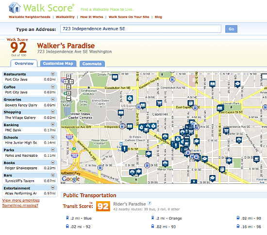
According to the Walk Score press release, ratings range from “Rider’s Paradises” where multiple transit options are available within a quarter of a mile to areas with limited or no nearby public transportation.
We mapped a few addresses across DC to get an idea of what areas offered better public transportation options than others.
- 1833 S Street NW
- 1326 R Street NW
- 6001 Utah Avenue NW
- 723 Independence Avenue SE
- 1524 Gales Street NE
See other articles related to: transit score, walk score
This article originally published at https://dc.urbanturf.com/articles/blog/walkscore_introduces_transitscore/2384.


UrbanTurf Listings showcases the DC metro area's best properties available for sale.

Most Popular... This Week • Last 30 Days • Ever
Janeese Lewis George appears to have won Tuesday's Democratic mayoral primary, puttin... read »

In this article, UrbanTurf explores what renters insurance is and what it covers.... read »

The largest waterfront redevelopment planned in the DC region in years has cleared it... read »
What will it take to get the H Street Corridor back on track? A new report from the D... read »

A renovation proposal is taking shape for a prominent historic office building along ... read »


DC Real Estate Guides
Short guides to navigating the DC-area real estate market
We've collected all our helpful guides for buying, selling and renting in and around Washington, DC in one place. Start browsing below!
First-Timer Primers
Intro guides for first-time home buyers
Unique Spaces
Awesome and unusual real estate from across the DC Metro