 The DC Neighborhoods At Risk of Flooding As Early As Next Year
✉️ Want to forward this article? Click here.
This week's release of drafted amendments to the Comprehensive Plan identify several new priorities for DC, including the need to study flood risks in certain swaths of the city. And there is one area that requires immediate attention.
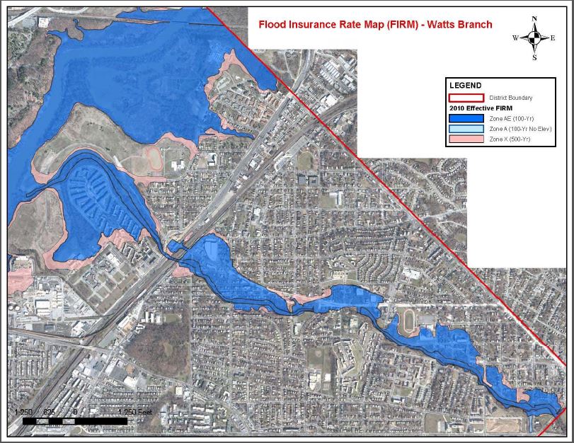
"The area around the Watts Branch, a tributary to the Anacostia River, is currently at risk of flooding, and is projected to be at increased risk as early as 2020," a newly-added section to the Far Northeast/Far Southeast Area Element reads. "The Watts Branch watershed encompasses multiple neighborhoods including Deanwood, Eastland Gardens, Kenilworth, Northeast Boundary, Mayfair, Parkside, and River Terrace. There is also a significant risk to dozens of public and community-serving facilities as well as affordable and public housing units."
Several of the above neighborhoods are the site of in-progress mixed income redevelopments, and the watershed of the Watts Branch also reaches Joint Base Anacostia Bolling and an electrical substation, as well as the Blue Plains Wastewater Treatment Plant. While DC Water is constructing a seawall to protect Blue Plains beyond 500-year flood standards, it is unclear what is being done to protect endangered residential neighborhoods.
story continues below
loading...story continues above
The Watts Branch watershed was identified as a resilience planning priority area in the 2016 Climate Ready DC report. The Environmental Protection Agency and jurisdictions traversed by the Watts Branch have studied flood risks there in recent years, as has the federal-local interagency group DC Silver Jackets; the Comp Plan states that Silver Jackets is currently testing mitigation strategies.
The Comp Plan seems to identify the sewage overrun mitigation from the ongoing DC Clean Rivers Project and efforts to shore up five Anacostia tributaries, including Watts Branch, as part of the solution to address flood risks. A new Implementation Element section also encourages more "neighborhood-scale and site-specific solutions" within neighborhoods which lie in the watershed.
If neighborhoods along the Watts Branch are indeed at increased risk of flooding within the next few months — potentially before the Comp Plan amendments are voted into law — how will residents there be affected?
See other articles related to: anacostia river, anacostia riverfront, comp plan, comprehensive plan, dc comprehensive plan, far northeast, far southeast, flood risk, flooding, flooding in dc, floodplain, northeast, resiliency, ward 7, watts branch
This article originally published at https://dc.urbanturf.com/articles/blog/are-some-east-of-the-river-neighborhoods-at-higher-risk-of-flooding-next-ye/16034.


UrbanTurf Listings showcases the DC metro area's best properties available for sale.

Most Popular... This Week • Last 30 Days • Ever
EYA and the Washington Metropolitan Area Transit Authority have requested a two-year ... read »

While the broader DC-area housing market grapples with elevated mortgage rates and ca... read »
From the Maryland line down to the edge of downtown, a mix of office conversions, inf... read »
Close-in suburbs are seeing some of the steepest rent declines in the region, while s... read »

Dulles International Airport is slated for its biggest transformation since it opened... read »


- Rising Costs Stall 434-Unit Takoma Metro Project, Developer Seeks More Time
- The DC-Area Luxury Market Is Playing By Its Own Rules
- 1,800 Units In The Works: Connecticut Avenue's Building Boom
- Across The DC Region, Rent Growth Is Splitting Along The Beltway
- Trump Administration Unveils $22 Billion Overhaul of Dulles International Airport
DC Real Estate Guides
Short guides to navigating the DC-area real estate market
We've collected all our helpful guides for buying, selling and renting in and around Washington, DC in one place. Start browsing below!
First-Timer Primers
Intro guides for first-time home buyers
Unique Spaces
Awesome and unusual real estate from across the DC Metro