 Where a New Silver Line Could Create New Metro Stops
✉️ Want to forward this article? Click here.
Last week, WMATA put forth six proposals to address congestion on Metro's Blue, Orange, and Silver Lines, one of which would create a Georgetown Metro station and extend a new Blue Line through DC into Prince George's County.
Two of the other proposals would create a new Silver Line. Below, we highlight the route those lines could take and the new stations which would be created along the way.
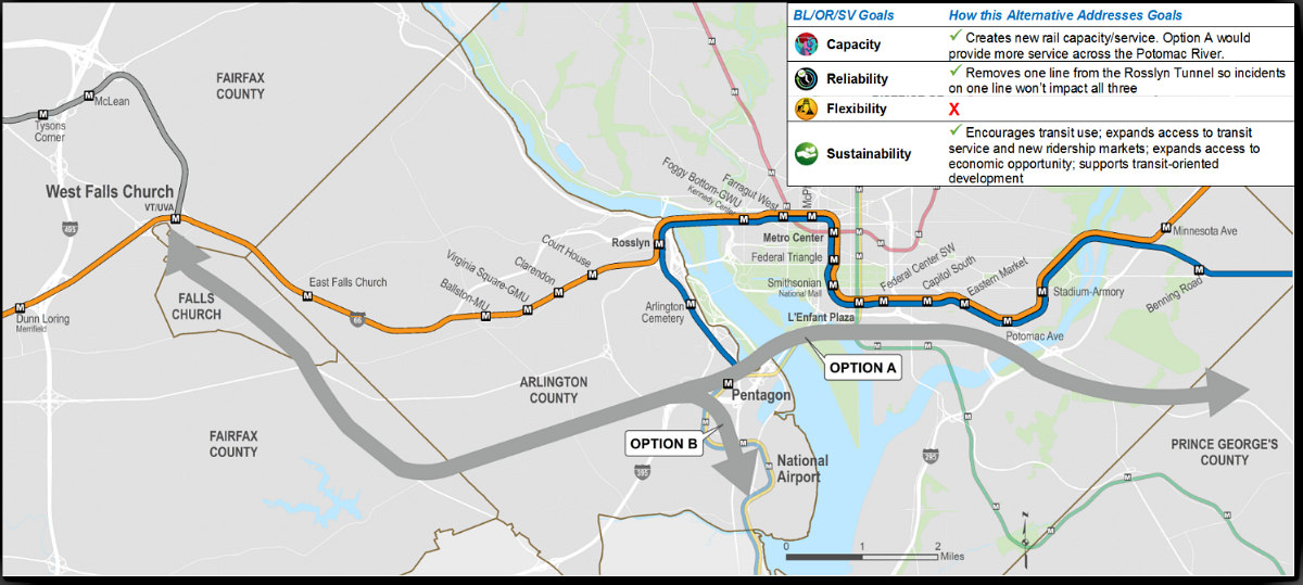
The Silver Line North option would run north of I-66, taking three potential routes. The first would begin at West Falls Church Metro station, while the second would begin at McLean Metro station. Either route would then cross the Potomac River and land near Georgetown Day School, going on to Dupont Circle, past Mount Vernon Square, then to Union Station. From there, the routes would go through Kingman Park and cross Benning Road into Prince George's County. Similar to the New Blue Line option, these routes could enable a Metro station near the Starburst intersection, as well as stops at the Arboretum and Capitol Crossing.
The third route would also begin at McLean Metro, then cross the Potomac north of Little Falls Stream Valley Park, pass Friendship Heights, then cross Rock Creek to the Georgia Avenue-Petworth and Rhode Island Avenue Metro stops before continuing into Prince George's County. This option could enable Metro stations at the intersection of Connecticut Avenue and Military Road, as well as near Bladensburg Road and South Dakota Avenue and Fort Lincoln.
The Silver Line South option would run south of I-66, starting at West Falls Church station and following Route 7 to connect with and follow Columbia Pike. From there, the line could have two potential routes, with the second route turning south to connect with Crystal City and National Airport. The first route would go across the Yellow Line bridge and into Southwest DC, traveling parallel to M Street SW. The route then crosses the Anacostia River and lands somewhere near Naylor Road, then exits into Prince George's County on a path proximal to Pennsylvania Avenue SE. While either of the Silver Line South options could create a stop at Bailey's Crossroads, as well as various points along Route 7 and Columbia Pike, the first option could also create a Metro station in Penn Branch, likely at the intersection of Pennsylvania and Branch Avenues.
As with the New Blue Line, any additional Metro stations which could be created by these routes are purely theoretical based on the route. The six proposals are part of WMATA's Blue/Orange/Silver Capacity and Reliability Study, for which the agency is holding public information sessions this month and soliciting feedback on the proposals. Check out the remaining proposals and locations for the meetings here.
See other articles related to: metro, metrorail, silver line, wmata
This article originally published at https://dc.urbanturf.com/articles/blog/where-a-new-silver-line-could-create-new-metro-stops/16235.


UrbanTurf Listings showcases the DC metro area's best properties available for sale.

Most Popular... This Week • Last 30 Days • Ever

UrbanTurf is re-running its primer on property taxes which outlines a few things that... read »

The wait for Eataly in the DC area has been a long one.... read »
The plan to add a shade structure along the Cleveland Park commercial corridor has re... read »

At the $1 million mark, DC's market offers strikingly different products depending on... read »

Justice Roberts selling Maryland home; bathroom danger; and what will future stadiums... read »


DC Real Estate Guides
Short guides to navigating the DC-area real estate market
We've collected all our helpful guides for buying, selling and renting in and around Washington, DC in one place. Start browsing below!
First-Timer Primers
Intro guides for first-time home buyers
Unique Spaces
Awesome and unusual real estate from across the DC Metro