 Rowing Machines and a Sky Deck: More Details Emerge About Georgetown Canal Redevelopment
✉️ Want to forward this article? Click here.
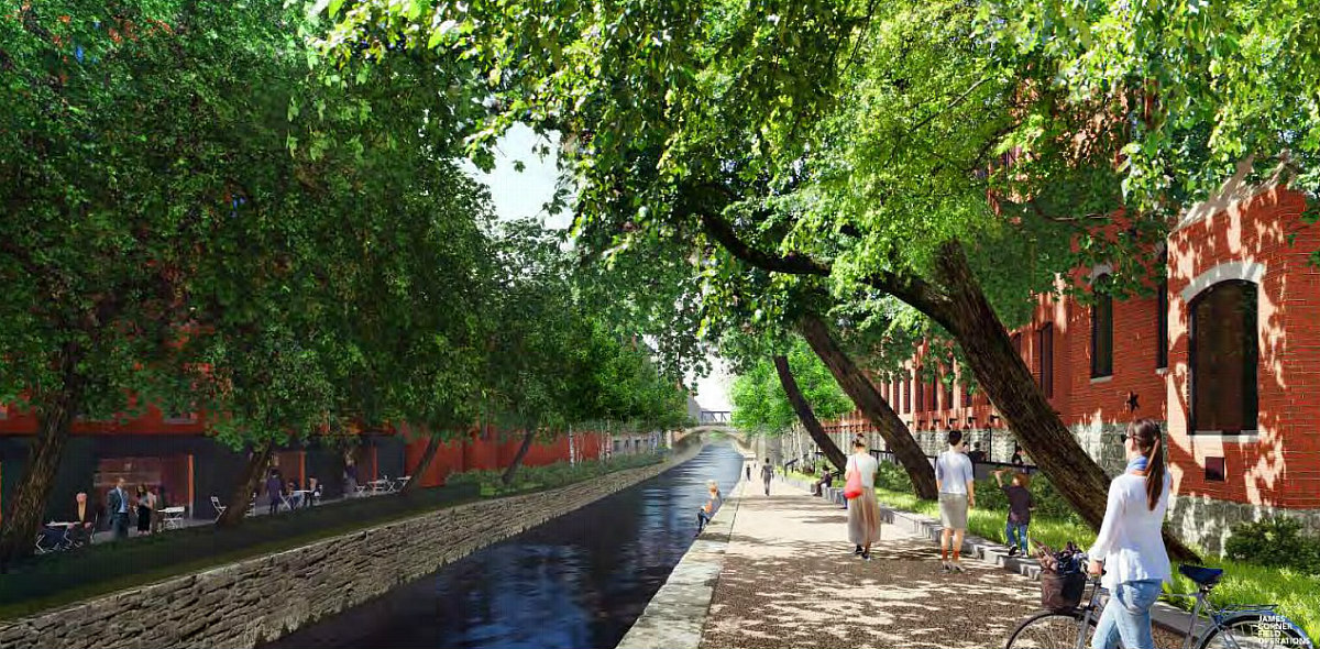
This spring, Georgetown Heritage and the National Park Service, along with design firm James Corner Field Operations, unveiled more precise design concepts for the envisioned reactivation of a mile-long stretch of the C&O Canal in Georgetown. Now, the Environmental Assessment has been released and the project team is soliciting public feedback on the design alternatives — or on whether anything more than basic restoration and maintenance should happen in the first place.
The assessment finds little lasting impact of construction along the Canal following conclusion of that work, and the project team would like to see a series of experiences and educational, interactive and relaxation opportunities in the identified areas. Here are some of the newer, and more interesting, details of what the proposed activation and construction would entail.
story continues below
loading...story continues above
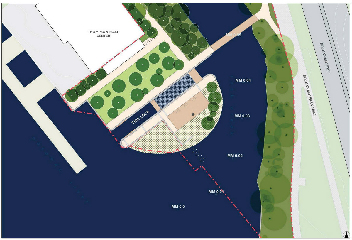
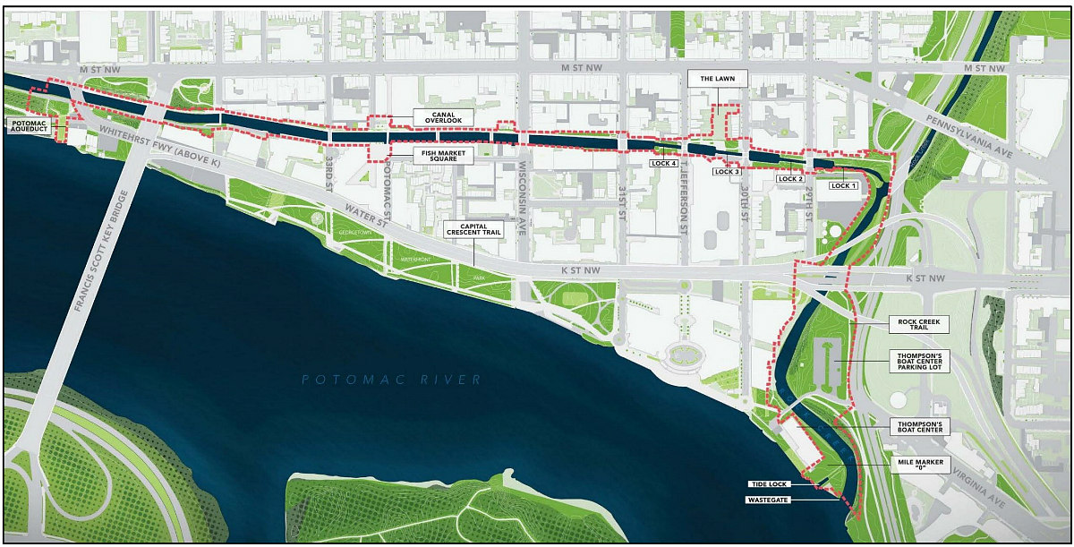
- In addition to the seasonal lounge nets spanning the Canal at Zone A (from Mile Marker Zero to just past K Street), the lawn northwest of the Tide Locks will be regraded and expanded from 290 to 4,800 square feet. There will also be a 1,000 square foot kiosk southeast of the Thompson Boat Center, and 6-12 stationery rowing stations and/or other nautical-referencing exercise equipment.
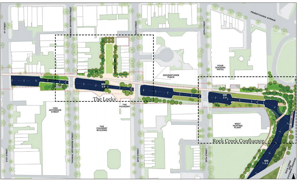
- In addition to the Rock Creek Confluence and Pollinator Meadows of Zone B (from the Rock Creek Trail to 31st Street), there will be a sculpture garden ("Me Amo Grove") across the Canal from Georgetown Place. The Locks will no longer have a relocated mule staging area, but will have seating steps to the north of Lock 3, a regraded plaza on the opposite bank, and 300 feet of murals along a lawn parallel to 30th Street. The existing visitor center will be renovated for use as NPS administrative space, and a new 12,000-14,000 square foot center will be erected on 30th Street. There will also be an opportunity to take an educational Georgetown Canal Boat between Mile Markers 0.50 and 1.12.
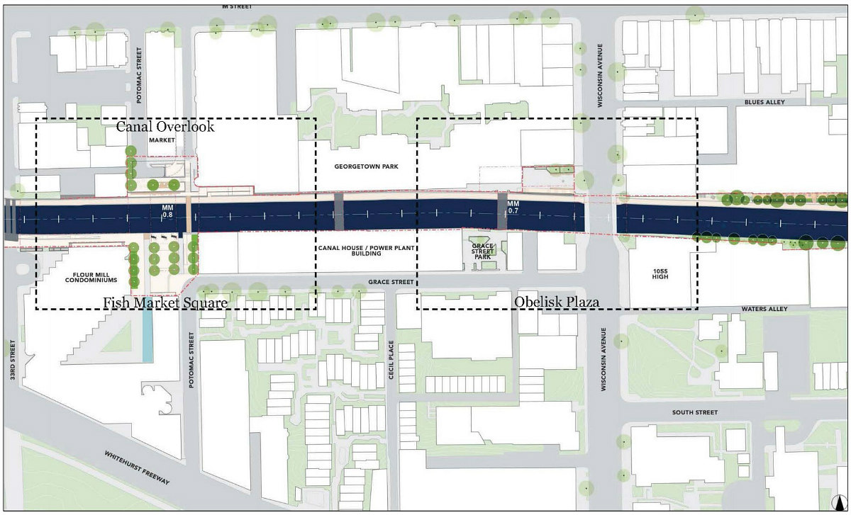
- An elevator will be installed between M Street and the Potomac Street Pedestrian Bridge in Zone C (between 31st and 33rd Street). The planted area above the entrance to the Georgetown Parking Garage will be replaced with a bi-level "Sky Deck"*. The stone steps and the archway at the Obelisk Plaza will be nixed, as will the boardwalk abutting the Canal House Condominiums. Meanwhile, the lower retaining wall will be reconstructed and seating added ("Wall Balcony and Seating Bench"*), and the Upper Retaining wall will be brought level with the Canal Overlook*.
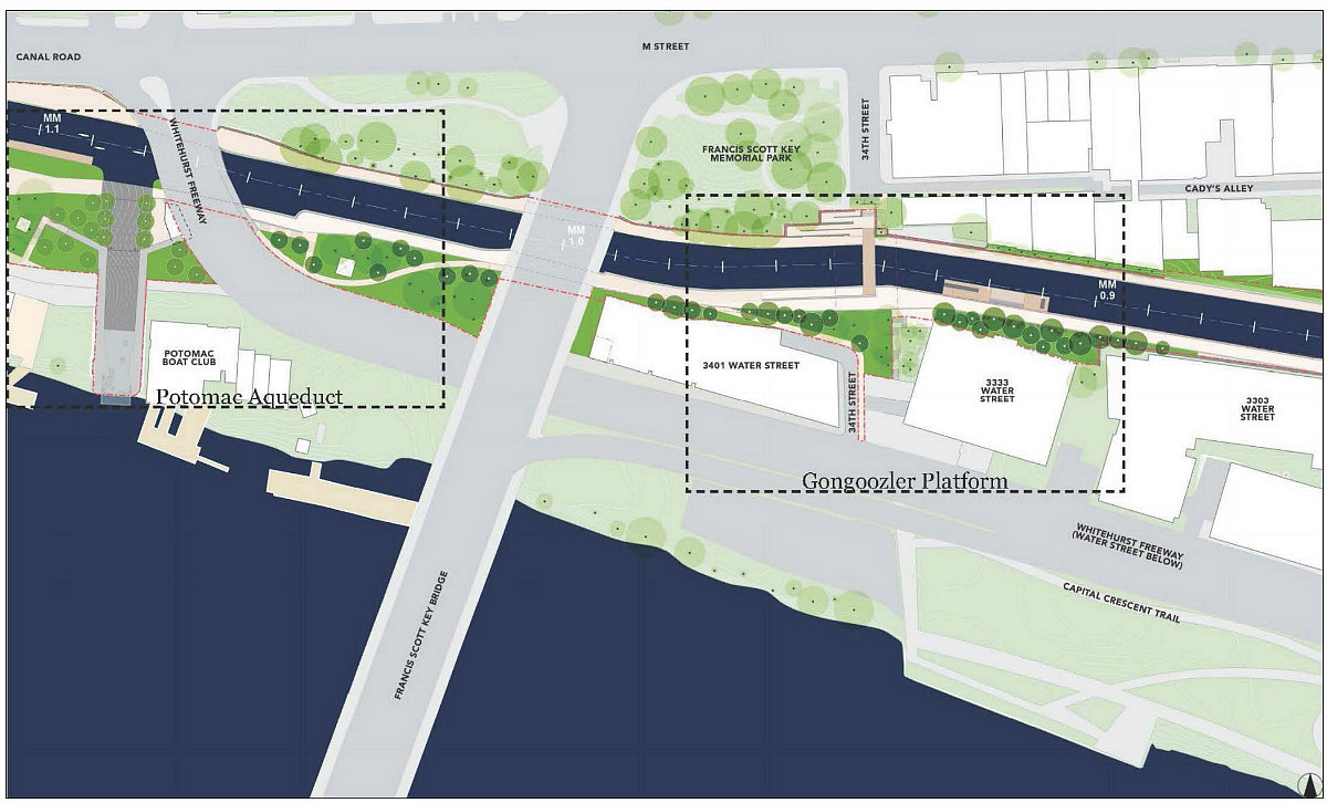
- In Zone D (from 3203 Water Street to past Whitehurst Freeway), a hydroelectric facility building on the opposite side of the freeway from the Potomac Boat Club will either be updated or repurposed into an educational experience. In addition to the gongoozling (or canal-watching) platform, there will be a regraded 1,000 square foot plaza at 34th Street and a 180 square foot Stone Yard Seating area, referencing the historic stone yard, south of the towpath. There will no longer be a canopy at the fish market; a trestle at the Potomac Aqueduct; nor boulder seating areas, a garden lounge, a kayak launch, and a platform near 3333 Water Street.
The parking lot just off Rock Creek Parkway will be expanded from 28,600 to roughly 46,000 square feet, in part to create room for a mule trailer for the Georgetown Canal Boat. There will also be a series of pedestrian bridges spanning and connecting different paths abutting the Canal, as well as several staircases which will be replaced, ramps which will be installed to and from the path, and points where the path will be resurfaced, regraded and widened.
There will be a public meeting on the project November 7th; the public comment period ends November 16th.
*These proposed features would be on private property and are contingent on the owner's approval.
See other articles related to: c&o canal, c&o canal renovation, environmental assessment, georgetown heritage, james corner field operations, national park service
This article originally published at https://dc.urbanturf.com/articles/blog/rowing-machines-and-a-sky-deck-more-details-emerge-about-planned-co-canal-r/16046.


UrbanTurf Listings showcases the DC metro area's best properties available for sale.

Most Popular... This Week • Last 30 Days • Ever

UrbanTurf is re-running its primer on property taxes which outlines a few things that... read »
The wait for Eataly in the DC area has been a long one.... read »
The Arlington County Board signed off on a pair of transformative residential project... read »
The plan to add a shade structure along the Cleveland Park commercial corridor has re... read »

DOGE doesn't seem dead yet; Monument buys Inn of Rosslyn; and Costco gas stations are... read »


DC Real Estate Guides
Short guides to navigating the DC-area real estate market
We've collected all our helpful guides for buying, selling and renting in and around Washington, DC in one place. Start browsing below!
First-Timer Primers
Intro guides for first-time home buyers
Unique Spaces
Awesome and unusual real estate from across the DC Metro