What's Hot: Douglas Development Files PUD For Large Warehouse At New City Site Along New York Avenue
 Navy Yard to Ward 8? Three Potential Maps of New DC Ward Boundaries Released
✉️ Want to forward this article? Click here.
As the DC Council Sub-Committee on Redistricting continues the city's redistricting process aimed at creating more population balance between DC's wards, three possible redistricting maps have been released for the public to consider.
Below, UrbanTurf takes a look at what solutions the draft maps suggest.
One of the impetuses behind the redistricting push is that the latest U.S. Census population count showed that DC's Ward 6 is grossly out of balance population-wise with the rest of the city, primarily due to the glut of residential development in the Southwest, Navy Yard, and NoMa/H Street neighborhoods. Each ward should have an average population of 86,193 people, although there is wiggle room of ±5%.
story continues below
loading...story continues above

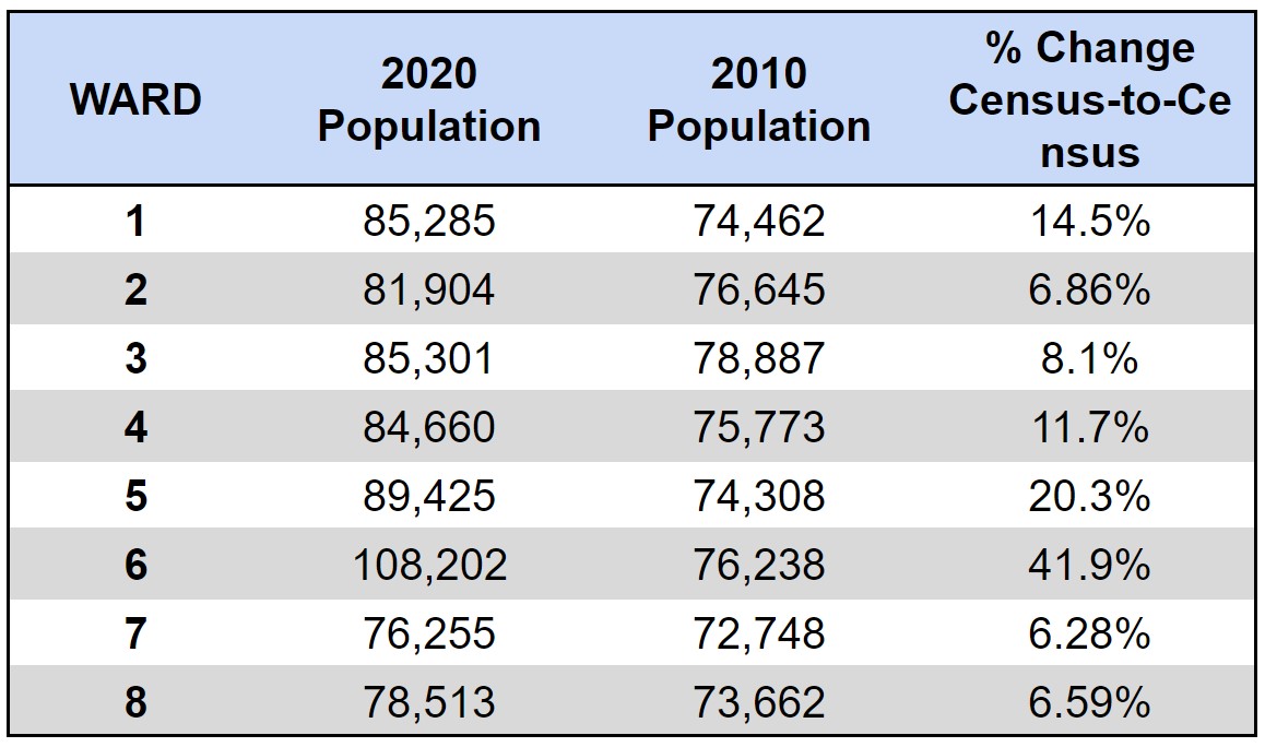
Option 1: Hill East to Ward 7, Navy Yard to Ward 8
In the first draft map, the populations of Wards 3 and 4 remain unchanged, while the other ward boundaries have been redrawn to rebalance population distribution. Ward 1 becomes the city's largest, population-wise, courtesy of its southern boundary shifting south to add the blocks north of S Street between 14th and 18th Streets; the half-block off S Street between 6th and 7th Street has been shifted to Ward 2. Ward 2 also gains the blocks northeast of 11th and P Streets to New Jersey Avenue NW from Ward 6.
South of Benning Road NE, Ward 7 becomes the second-largest ward by population, with its west boundary moving further in to terminate at 15th Street NE/SE and Pennsylvania Avenue, then taking up more of the Fairlawn neighborhood east of the Anacostia River before rejoining with Good Hope Road and Naylor Road. Ward 8 gains the Navy Yard neighborhood (southeast of South Capitol Street and 695), and Ward 5 stays mostly the same with the exception of the Armed Forces Retirement Home and the hospital campus below going to Ward 1.
Because avoiding dilution of minority voting representation is a primary concern in the redistricting process, ANC Commissioner Corey Holman noted that this map option would decrease Ward 2's white voting-age population by 1.3% while increasing the Black population by the same measure (Ward 2 is currently 64.3% white); in Ward 6, currently 55.3% white, the population of voting-age white residents would increase a half-percent and the population of voting-age Black residents would decrease by 1.1%. Meanwhile, Ward 7's (88.6% Black) voting-age white population would increase by 4.6% while the voting-age Black population would decrease by 5.1%, and Ward 8's (88.9% Black) voting-age white population would increase by 10.1% and voting-age Black population would decrease by 11.7%.
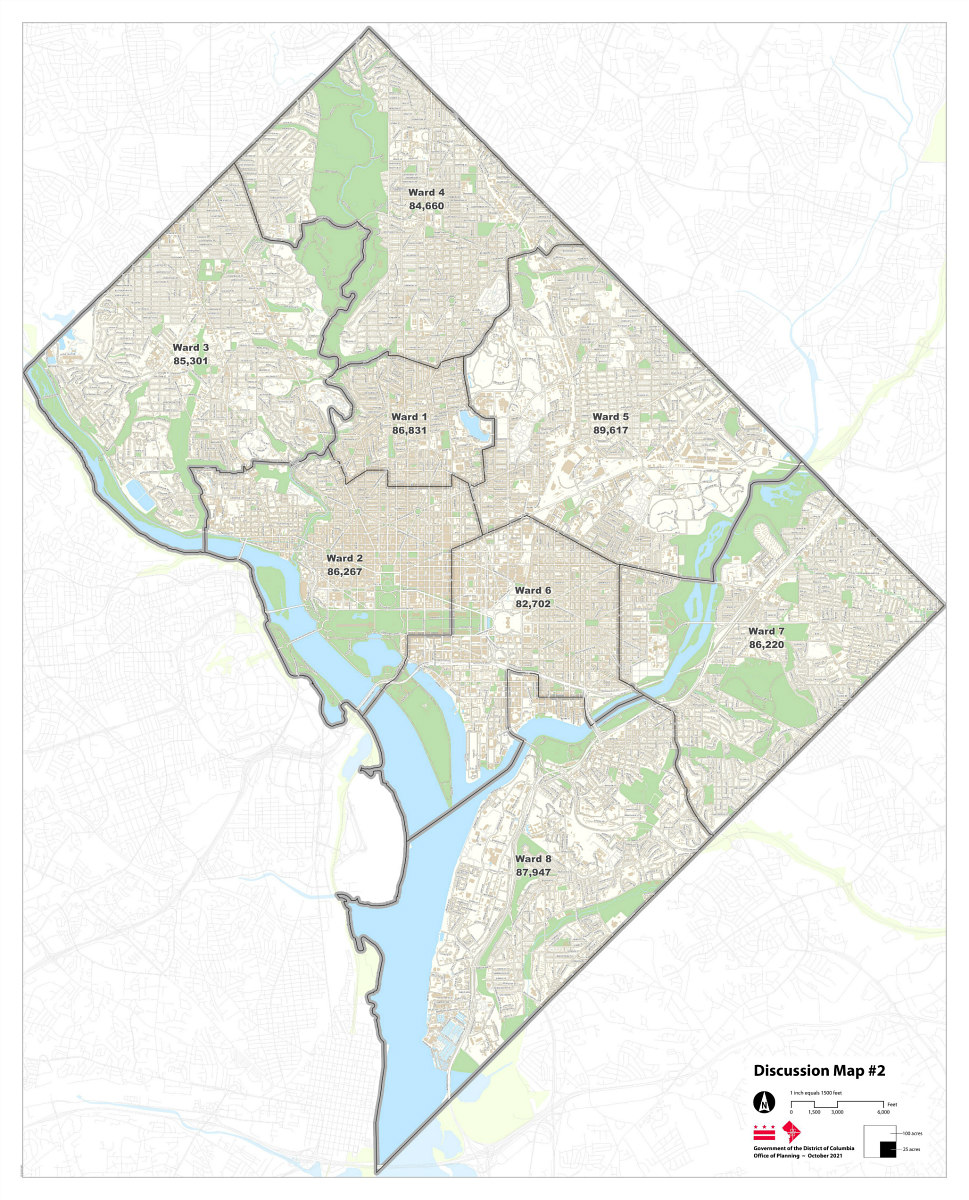
Option 2: Hill East to Ward 7, Subtler Changes Elsewhere
In the second draft map up for discussion, the populations of Wards 3 and 4 remain unchanged, and Ward 1 doesn't change much besides the S Street southern boundary spanning from 7th to 18th Streets NW. Ward 2 would gain the blocks northeast of 11th and P Streets to New Jersey Avenue NW from Ward 6, ending west of 7th Street and north of New York Avenue.
South of Benning Road NE, Ward 7's west boundary would also terminate at 15th Street NE/SE and Pennsylvania Avenue in this instance, but would remain relatively the same east of the River before rejoining with Good Hope Road and Naylor Road. Ward 8 would get less of the Navy Yard neighborhood courtesy of a carve-out south of I-695 and northeast of 3rd and M Streets SE.
Per Commissioner Holman's count, this map option would decrease Ward 2's white voting-age population by 2% while increasing the Black population by 2.6%. Ward 6's voting-age white population would increase by 1.4% and the population of voting-age Black residents would decrease by 2.4%. Ward 7's voting-age white population would increase by 4.8% while the voting-age Black population would decrease by 5.4%, and Ward 8's voting-age white population would increase by 8.9% and voting-age Black population would decrease by 10.2%.
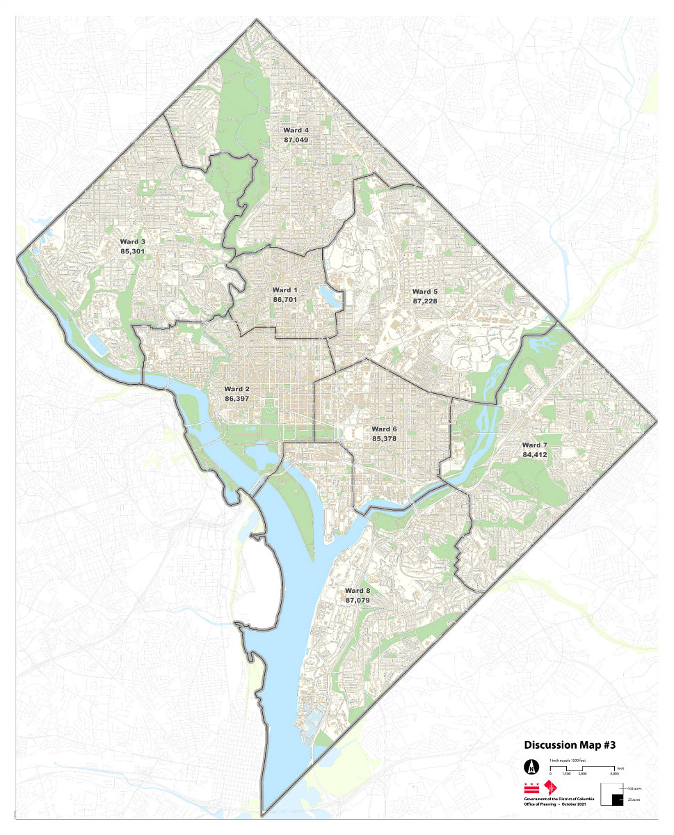
Option 3: Southwest to Ward 8, Nearly Equal Population Across Wards
The third draft map makes slight adjustments to each ward boundary, subsequently making the ward populations relatively even across the board. The southeastern border of Ward 4 is nudged further south past Riggs Road to meet Galloway Street. Ward 1's S Street boundary goes from 15th Street to New Jersey Avenue NW, and Ward 3 remains unchanged.
Ward 2 gains the blocks northeast of 11th and P Streets to New Jersey Avenue NW from Ward 6, terminating at 7th Street south of New York Avenue NW. Ward 8 gains the Southwest neighborhood from south of Independence Avenue, and Ward 7 gains the blocks between Naylor Road and Suitland Parkway. The changes to Ward 7 don't end there, as the westward boundary would become uniform along 19th Street while also absorbing the blocks southeast of 17th Street and Potomac Avenue SE; the blocks southwest of 25th and Pennsylvania Avenue SE would also go from Ward 7 to Ward 8.
By Commissioner Holman's count, this map would have the same effect on Ward 2's voting-age population as that of Option #2, and the effect on Ward 7's voting-age population would be negligible. Ward 6's population of voting-age white residents would increase by 3.7% and the population of voting-age Black residents would decrease by the same measure, and Ward 8's voting-age white population would increase by 9.9% and voting-age Black population would decrease by 12.9%.
There have already been public hearings specific to seven of the wards, and there will be two additional public hearings, on the Ward 6 boundaries and on the expected redistricting as a whole, later this week. A redistricting proposal will then be submitted to the DC Council for a first vote early next month; a final redistricting bill is expected to pass by the end of the year.
Similar Posts:
See other articles related to: dc wards, population, redistricting
This article originally published at https://dc.urbanturf.com/articles/blog/navy-yard-to-ward-8-three-maps-of-potential-new-ward-boundaries/18898.


UrbanTurf Listings showcases the DC metro area's best properties available for sale.

Most Popular... This Week • Last 30 Days • Ever

When you buy a home in the District, you will have to pay property taxes along with y... read »
The largest condominium building in downtown DC in recent memory is currently under c... read »
The plan to convert a Dupont Circle office building into a residential development ap... read »
The Rivière includes just 20 homes located on the eastern banks of the Anacostia Riv... read »

Why Tyra Banks is serving ice cream in DC; a bike shop/record store opens in Adams Mo... read »


DC Real Estate Guides
Short guides to navigating the DC-area real estate market
We've collected all our helpful guides for buying, selling and renting in and around Washington, DC in one place. Start browsing below!
First-Timer Primers
Intro guides for first-time home buyers
Unique Spaces
Awesome and unusual real estate from across the DC Metro