 Greater Greater Washington's DC Metro-Circulator Map
✉️ Want to forward this article? Click here.
Greater Greater Washington has put together a very impressive map that combines the new DC Circulator routes with the existing DC Metro system. Check it out below, or for a larger version, click here.
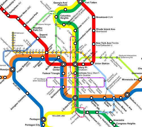
Greater Greater Washington’s Metro-Circulator Map
The map includes both new Circulator routes: the first (in light green) which runs between Woodley Park and McPherson Square through Adams Morgan, Columbia Heights, U Street and Logan Circle, and the second (in light blue) which connects Union Station with Barracks Row and Nationals Park. Also included on the map are the H Street Shuttle and the Georgetown Metro Connection.
This article originally published at https://dc.urbanturf.com/articles/blog/greater_greater_washingtons_dc_metro-circulator_map/735.




UrbanTurf Listings showcases the DC metro area's best properties available for sale.
Most Popular... This Week • Last 30 Days • Ever

DC is discussing borrowing a page from NYC's tax playbook.... read »
UrbanTurf crunched the year-to-date figures across the city, and found five zip codes... read »

A year-old change to Montgomery County's zoning code could shave months off the appro... read »
Mortgage applications ticked up last week and there was a notable shift is in how bor... read »

DC's old taxi zone system; a new study finds light pollution hits Wards 7 and 8 harde... read »






DC Real Estate Guides
Short guides to navigating the DC-area real estate market
We've collected all our helpful guides for buying, selling and renting in and around Washington, DC in one place. Start browsing below!
First-Timer Primers
Intro guides for first-time home buyers
Unique Spaces
Awesome and unusual real estate from across the DC Metro

