What's Hot: 1,080 Homes, a Costco and a New Neighborhood: An Early Look at Viva White Oak's First Phase
 Google Maps Launches Live Public Transit Alerts for DC
✉️ Want to forward this article? Click here.
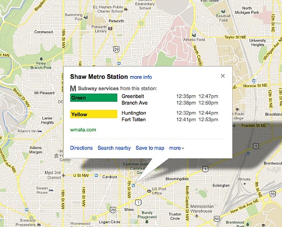
Courtesy of Google Maps.
Google Maps announced updates today for its tracking of live departure and arrival times for DC’s bus and subway system.
From the Google Maps blog:
Riders on the nation’s second largest subway, Metrorail in Washington, D.C., can now see live service alerts, including unplanned delays and scheduled track work, straight from Metro’s Control Center on Google Maps. To adjust your travel around the alerts you see, simply choose another suggested route or change your departure time.
Given DC’s previous attempts at tracking public transit arrival and departure times, we will be interested to see how the update will affect the accuracy of the tool.
Similar Posts:
- Google Showcasing SketchUp Designer Creations
- Do Google Searches Predict the Direction of Home Prices?
See other articles related to: google, google maps, google transit
This article originally published at https://dc.urbanturf.com/articles/blog/google_maps_updates_live_public_transit_alerts_for_dc/6845.


UrbanTurf Listings showcases the DC metro area's best properties available for sale.

Most Popular... This Week • Last 30 Days • Ever

When you buy a home in the District, you will have to pay property taxes along with y... read »

The first residential piece of one of Montgomery County's largest developments is com... read »
A Columbia Heights lot that has sat empty for more than a decade could soon be home t... read »

The final phases of one of Northeast DC's largest developments are going to need a li... read »

Sellers asking for AI stock instead of cash, Nvidia lands downtown, and a closer look... read »


- First-Timer Primer: Tax Relief for DC Homeowners
- 1,080 Homes, a Costco and a New Neighborhood: An Early Look at Viva White Oak's First Phase
- 30-Unit Building Proposed For Long-Vacant Columbia Heights Lot
- Restaurants, Recreation Venue in the Works as Art Place Seeks More Time for Final Phases
- Friday's Must Reads
DC Real Estate Guides
Short guides to navigating the DC-area real estate market
We've collected all our helpful guides for buying, selling and renting in and around Washington, DC in one place. Start browsing below!
First-Timer Primers
Intro guides for first-time home buyers
Unique Spaces
Awesome and unusual real estate from across the DC Metro