The Latest Re-Design of the DC Metro Map

by Mark Wellborn

The DC Metro map has been reinvented by artists over the years, but a Portland-based graphic designer just released a fairly clean and intuitive re-interpretation that UrbanTurf is fond of.

Cameron Booth is a graphic designer with a 16-year resume with an admitted passion for transit maps. Having already done a poster of US interstates in the style of the London Underground’s Tube Map, Booth was looking for a new project when he decided on the WMATA map.

“I’m going to be blunt here. I simply don’t like the current one,” Booth told UrbanTurf. “Heresy, I know, but there it is.”
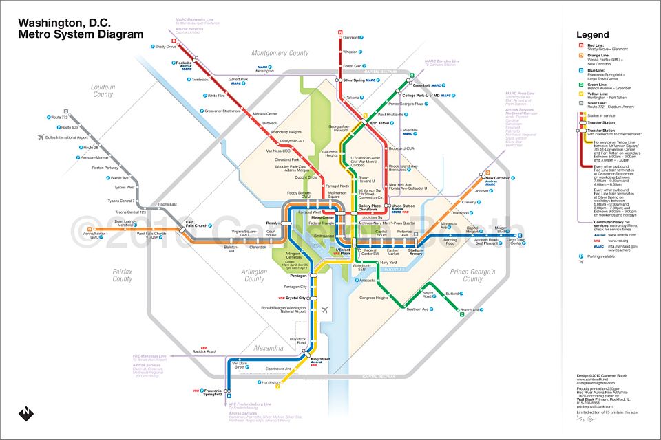
image
Click to enlarge

Booth’s “design brief” when approaching the project was to make the map as different as possible to the current one while retaining all information, cleaning up some errors (station placement relative to the District’s “diamond”, mainly), and adding the Silver Line. The new map has thinner route lines (to make the map look more elegant) and Booth added in Amtrak and MARC/VRE routes and connections to the map. He admits that opinions are divided about whether or not the inclusion of the Amtrak and MARC lines were useful, but like the map itself, his aim was to incite discussion.

“I designed this to inspire some debate about the current map,” Booth said. “Is it the ‘design classic’ that some people think, or is it a poorly-drawn, dated-looking relic of the 1970s?”

Booth’s re-interpretation is now for sale. For more info about the genesis of the design, click here.

See other articles related to: wmata, metro, cameron booth

This article originally published at http://dc.urbanturf.com/articles/blog/the_latest_redesign_of_the_dc_metro_map/2717

15 Comments

  1. Jorell said at 5:50 pm on Tuesday November 30, 2010:

    Christmas gifts!

  1. WMATA Fan said at 7:14 pm on Tuesday November 30, 2010:

    Much better than the current version.

  1. Jerry said at 8:20 pm on Tuesday November 30, 2010:

    How is this better?  You can’t read it from a distance, it looks just like any other transit map out there, and it’s basically a zoomed out version of what we already have.  Mebbe you couldn’t improve on the original because it’s already well designed?  MARC/VRE connections?  If you even know what those are, you already know where you need to go to make the trains.  I’m a big fan of design, but I don’t see how this is any more than a me too iteration of a map that’s already one of the best designed I’ve seen.

  1. Richard Daley III said at 9:02 pm on Tuesday November 30, 2010:

    Wonderful map.  Looks just like the way we used to print them.  Easy to tell where trains meet and Now if you only could make your fares like ours, you’d be working on not being a hick town used like two-bit ho’s on Cicero Ave by all the good “southeners” in VA and MD and every other Tom Harry Dick.  Go Bears!

  1. Cameron Booth said at 10:34 pm on Tuesday November 30, 2010:

    Well, these comments just prove what I’ve already seen since I first designed this diagram in February (long before the current talk of WMATA redesigning it) - people either love it or hate it!

    I will say one thing about the size of the type, just because I’m tired of people saying that the diagram is unreadable based off a 1200px wide JPG. The type is exactly the same size as the current diagram. If you make the District’s diamond the same size on both versions, the type is exactly the same. Just sayin’.

  1. jag said at 10:48 pm on Tuesday November 30, 2010:

    Yeah, I don’t know how someone could say it’s unreadable…you need the lines to be super thick in order to tell what color they are or something? I definitely like this design.

  1. Andy said at 12:02 am on Wednesday December 1, 2010:

    I like it aesthetically, but I think the station labels for most of the downtown stations are way too close together and would be confusing, especially to a visitor. For example, the Farragut West label is almost directly underneath Foggy Bottom, Judiciary Square label could be confused with Gallery Place, Gallery Place label with Union Station, Federal Center SW label with L’Enfant Plaza, etc. I’m guessing you intentionally avoided using using diagonal labels?

  1. Cameron Booth said at 12:16 am on Wednesday December 1, 2010:

    Absolutely! Diagonal type on a diagram has its place, but I find the usage on the current Metro diagram to be fairly disappointing - it comes in from the left and the right, and in a couple of places, isn’t even at an exact 45 degree angle! So I definitely tried to take an opposite approach. Farragut West and Metro Center are the only ones I’m perhaps not 100% happy with: the alignment of the others gives away which station they’re connected to. Erik Spiekermann actually told me that any designer who has to angle type on a diagram is - and I quote - “a loser”. He should know, he did the Berlin diagram in 1993 after reunification.

  1. Joe in SS said at 11:08 am on Wednesday December 1, 2010:

    Aesthetically, the biggest thing that bugs me is the northwest corner of the beltway, looking like a misshaped forehead.  I understand why it’s done, but it always jumped out at me… 
    Functionally, I believe that that the Red Line trains turning back at Grosvenor was eliminated earlier this year?  (They still turn back at Silver Spring during all but late nights.)  I like the inclusion of MARC/VRE, but I’d add the airport buses, shown with an airplane symbol as they are on the NYC Subway map (the M60 to Laguardia).

  1. WoodsideParkBob said at 11:36 am on Wednesday December 1, 2010:

    This map, like the current metro map, fails to recognize that the Montgomery County - Prince Georges County line is no longer straight inside the Beltway.  The line needs to be jogged a bit to recognize that Takoma Park is now entirely in Montgomery County.

  1. Cameron Booth said at 12:42 pm on Wednesday December 1, 2010:

    @ Joe in SS: Someone needs to tell Metro that the turnback at Grosvenor has been eliminated, as all the maps I can find on their site still have the giant call out box about it. Can anyone confirm this (with a link/URL to proof) before I go to print?

    Re: Buses. I was told that the 5A to Dulles would be eliminated once the Silver Line was operational, hence its absence. If the B30 to BWI would still be running, I guess I should show that…

    @WoodsideParkBob: the straightness or otherwise of the county line is irrelevant on a simplified diagram (note I say diagram, not map!) like this: all we need to see is that there is a boundary that runs *generally* in the indicated direction.

  1. K. said at 1:36 pm on Wednesday December 1, 2010:

    Love it! Elegant and sleek, yet to the point.

  1. hallock said at 2:40 pm on Wednesday December 1, 2010:

    I like it almost entirely - but my only complaint is that the radius used for some turns is different than others. Since this is a diagram - I’d suggest tha the difference between the radii be lessened.
    Also on this map it makes it look like Faragut North and West are really far apart when in fact they are very close - anyone to fix that?
    Overall I really like it - a nice update.

  1. Karl said at 4:11 pm on Friday December 10, 2010:

    The Virginia side of the beltway was made to look much larger from 270 to Oxon Hill than the Prince Georges side (270 to Oxon Hill). When in actuality the PG side is the greater distance.  The map is out of porportion and useless.

  1. Meghan S. said at 11:18 am on Tuesday December 21, 2010:

    Cameron forgot one major component… this map could never be installed throughout Metro stations and Metro trains. All wall-spaces within trains that are allocated to maps are vertical in nature. All free-standing map displays in stations are also vertical.

    For a re-design to be successful, we need a straight swap.

Join the discussion


* required fields

Ethan Carson

Coldwell Banker

202-302-0438

Serving:

Adams Morgan

Kalorama

Capitol Hill

UrbanTurf Archive

Following are past UrbanTurf stories, organized by topic for your convenience.

Neighborhood Profiles more »

Trinidad: The Difference 5 Years Makes

Trinidad: The Difference 5 Years Makes

Shilpi Paul
February 15th | 29 Comments

Five years ago, the DC police department was setting up police checkpoints in the Northeast DC... read »

Editor's Choice more »

A Gondola and a Metro Station? Georgetown in 2028

A Gondola and a Metro Station? Georgetown in 2028

Shilpi Paul
June 14th

Compared to rapidly transforming areas like 14th Street, NoMa and the H Street Corridor, Georgetown... read »

New Condo Profiles more »

20-Unit Columbia Heights Residential Project Expects Mid-2014 Delivery

20-Unit Columbia Heights Residential Project Expects Mid-2014 Delivery

Shilpi Paul
June 13th | 2 Comments

UrbanTurf got our hands on a new rendering and additional details for Madison Investments' 20-unit... read »

The DC Condo Market more »

Mount Pleasant Church May Become 70-Unit Condo Project

Mount Pleasant Church May Become 70-Unit Condo Project

Shilpi Paul
June 19th | 7 Comments

Keeping up with the trend of parking-free developments, the new owners of Meridian Hill Baptist... read »

Green Real Estate more »

Harvest Home: DC’s Submission For the 2013 Solar Decathlon

Harvest Home: DC’s Submission For the 2013 Solar Decathlon

Shilpi Paul
May 15th | 3 Comments

DC's entry into the Solar Decathalon is a net-zero home that generates energy primarily by... read »

Deal of the Week more »

Deal of the Week: U Street Condo Alternative With Rental Prospects

Deal of the Week: U Street Condo Alternative With Rental Prospects

Shilpi Paul
March 26th | 7 Comments

While the price per square of this installment of Deal of the Week is fairly average, the lower... read »

Renting more »

Report: DC Renters Save 30% By Living With a Roommate

Report: DC Renters Save 30% By Living With a Roommate

Shilpi Paul
June 18th | 2 Comments

Lovely, the rental home search website, has been sifting through their data to find out exactly how... read »

Market Watch more »

Market Watch: Logan Circle, Columbia Heights, Dupont Circle

Market Watch: Logan Circle, Columbia Heights, Dupont Circle

Keith Gibbons
November 28th | 5 Comments

Housing Market Watch returns this week after a little hiatus as Keith Gibbons takes a closer look... read »

Unique Spaces more »

DC’s One-Room House

DC’s One-Room House

Shilpi Paul
May 2nd | 9 Comments

For those with the budget for a studio but the hankering for a house of their own, a one-room... read »

This Week's Find more »

This Week’s Find: Inspired By California in Takoma Park

Inspired By California in Takoma Park

Shilpi Paul
May 16th | 1 Comment

If This Week's Find looks a little out of the ordinary for Takoma Park, it's because it was... read »

UrbanTurf Reader Asks more »

UT Reader Asks: What Can You Do If Your Contractor Stops Working?

UT Reader Asks: What Can You Do If Your Contractor Stops Working?

Shilpi Paul
May 29th | 7 Comments

In this installment of UrbanTurf Reader Asks, a DC homeowner wonders what to do when his contractor... read »

What X Buys You more »

What $825,000 Buys You On Capitol Hill

What $825,000 Buys You On Capitol Hill

Shilpi Paul
June 19th | 1 Comment

In What X Buys You this week, UrbanTurf takes a look at properties on the market in the $825,000... read »

Best New Listings more »

Best New Listings: Modern, Capitol Hill, and a Stone Porch

Best New Listings: Modern, Capitol Hill, and a Stone Porch (Week of Jun 14th)

Shilpi Paul
June 14th | 1 Comment

In this week's edition of Best New Listings, UrbanTurf looks at a new condo in Mount Vernon Square,... read »

Luxury Real Estate more »

Dominique Strauss-Kahn’s Georgetown Home Finds A Buyer

Dominique Strauss-Kahn’s Georgetown Home Finds A Buyer

UrbanTurf Staff
June 14th | 0 Comments

UrbanTurf has learned that the DC home of Dominique Strauss-Kahn has finally sold. ... read »