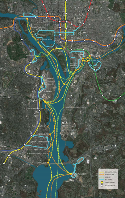
 What a Large Water Transportation Network Would Look Like in the DC Area
A lot of development has been sprouting up along the regional riverfronts, from National Harbor in Prince George's County to the first phase of The Wharf to plans for The Yards, C&O Canal and Poplar Point. However, between the roadways and public transportation, the accessibility from various points along the rivers is still lacking.
Here is how a regionwide water-surface transportation network could look — and how it could be successful.
Architecture firm Winstanley Architects and Planners has taken on this question as a passion project since commissioning an 8-minute ride with the Potomac Riverboat Company (PRC) from National Airport to the future redevelopment site at the former Coast Guard headquarters in Buzzard Point.
When real estate broker David Mayhood agreed that having such a convenience would increase real estate values for the condos at the development, Michael Winstanley began to explore how a larger river-transportation network could benefit the entire region.
As envisioned, this network could serve commuters throughout the region, as well as the federal government, military personnel, and tourists and taxi riders. The former two groups are regularly making inefficient trips from one side of either of region's rivers to the other, typically using personal vehicles to drive along two coastlines before being able to cross. All of this regional travel exacerbates congestion on already-burdened highways.
The thinking is that waterway transportation could alleviate some of that burden in a cost-effective, environmentally-friendly manner while also serving as an added tourist attraction and bolstering the region's emergency preparedness should evacuation routes be needed. This is far from a foreign concept, with similar examples already functioning in cities like Boston, Seattle and, of course, New York. There are also waterway transportation routes already in operation in the area, albeit more in the tourist/taxi category, such as that provided by PRC between The Wharf, Nationals Park, Old Town Alexandria and the National Harbor.
An expanded system could stop at dozens of additional landings, including such locations as The Mall, the Kennedy Center, Georgetown, RFK Stadium, Jones Point and the Joint Base Anacostia-Bolling.
story continues below
loading...story continues above
These landings would be designed as intermodal transit centers with connections to the local public transit options. Although dozens of landings could be constructed with private dollars by the developers whose projects would benefit, most of the potential landing sites are owned by the federal government and controlled by the National Park Service.
Establishment of the waterway network would require coordination between not only the federal government, Maryland, Virginia and DC, but also would need cooperation from the governments of various municipalities whose residents could benefit from the network. For this reason, Winstanley recommends that an agency or authority should be created to have oversight specifically over the waterways and waterfronts throughout the region and has the power to steer implementation of such a system.
The firm also regards a stop at National Airport — and some method of fare subsidizing, most recently made famous by the DC streetcar — as the ideal catalyst to spur on development of a wider water-transit network.
"From my perspective, an airport stop would absolutely jump-start the entire network, and most of the people that we spoke to are very interested in the airport stop," Winstanley told UrbanTurf.
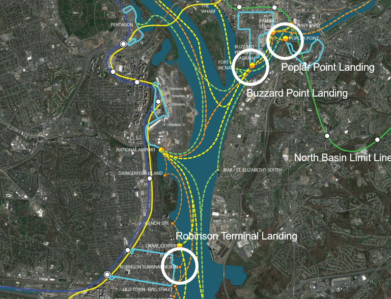
Three specific potential landings were explored, all of which are in the public right-of-way:
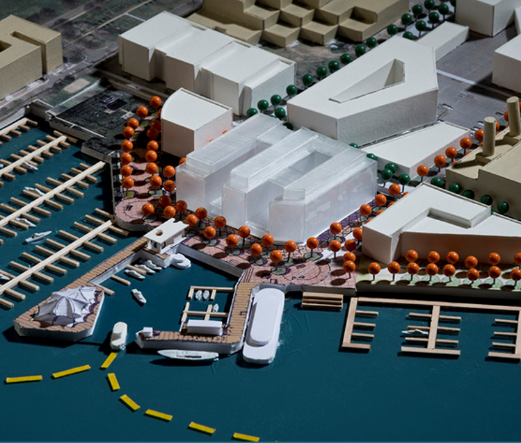
- Buzzard Point. This harbor would have an intermodal transit hub at the bottom of 2nd Street SW, adjacent to the River Point Harbor development at the former Coast Guard headquarters (map). The landing would also have a floating restaurant and a tent-covered music venue, as well as route connections to the landings at Nationals Park, Old Town, Poplar Point, and north to The Mall, The Wharf and Georgetown. DC has already planned to offer a shuttle service that travels via M Street between this area and the nearby Metro stations.
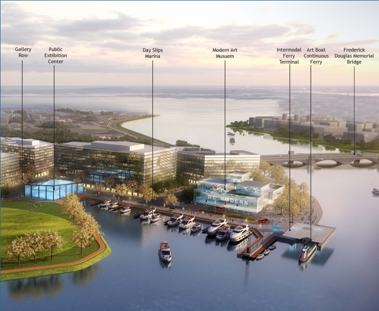
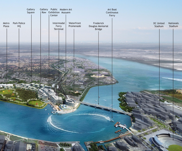
- Poplar Point is envisioned to be the terminus of a New Jersey Avenue extended cross-river from the Navy Yard neighborhood. A trolley would go from the landing along Howard Road to Anacostia Metro station. The development of Poplar Point would create an arts district with sculpture park, modern art museum and galleries. An "Art Boat" would run continuously, shuttling riders between Buzzard and Poplar Points.
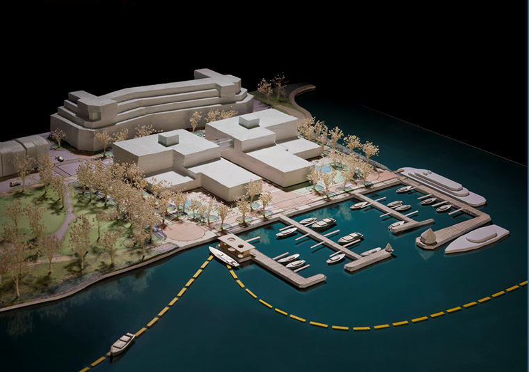
- An intermodal landing has also been designed for the terminus of Oronoco Street (map) at Robinson Terminal North. Alexandria has zoned the site for a hotel with residences across the street. This marina will also have a floating restaurant and would connect to a landing proximal to King Street.
While the logistical matters involved are relatively simple, a tremendous amount of political will and momentum would be necessary to execute such an expansive transportation network in the region's waterways. If it works, however, it could certainly go a long way to preparing the area to support an epicenter with a population of one million people.
See other articles related to: anacostia riverfront, capitol riverfront, riverfront, robinson terminal south, water surface transportation, water transit, waterfront, winstanley architects
This article originally published at https://dc.urbanturf.com/articles/blog/water-surface-transportation/13834.


UrbanTurf Listings showcases the DC metro area's best properties available for sale.

Most Popular... This Week • Last 30 Days • Ever

DC's homebuyer assistance programs can be a bit complex. This edition of First-Timer ... read »
When it comes to financing a home purchase, a 30-year mortgage is one of the most com... read »

Pocket listings are growing in popularity in the low-inventory market in the DC regio... read »

Margarite is a luxury 260-apartment property known for offering rich, high-end reside... read »
The owner of 700 Monroe Street NE filed a map amendment application with DC's Zoning ... read »


DC Real Estate Guides
Short guides to navigating the DC-area real estate market
We've collected all our helpful guides for buying, selling and renting in and around Washington, DC in one place. Start browsing below!
First-Timer Primers
Intro guides for first-time home buyers
Unique Spaces
Awesome and unusual real estate from across the DC Metro