 Underwater Innings: New Software Shows Where Rising Sea Levels Would Impact DC
Several months ago, UrbanTurf reported on DC's readiness to withstand a massive 500-year storm. Now, new software from Google illustrates where the city would be submerged should sea levels rise dramatically.
Google Earth has a new plug-in, courtesy of Climate Central, called Surging Seas: Extreme Scenario 2100 that can be activated when looking at various cities. The map allows you to zoom in in 2D and 3D to see how some of America's major coastal cities would appear if sea levels were to rise by 8 feet.
National Geographic states that sea levels rose by 8 inches over the past century, but that accelerated climate change over the past 20 years has caused sea levels to rise by 0.13 inches annually. With that calculus in mind, the sea level rise pictured here could theoretically happen by the year 2100.
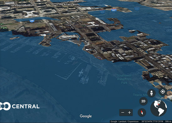
As was highlighted in the 500-year storm discussion, much of DC's monument and museum corridor would experience heavy flooding, particularly along Constitution Avenue and the land surrounding the Tidal Basin. However, residents in the Southeast and Southwest quadrants may have a lot more to worry about if sea levels did indeed rise by eight feet.
story continues below
loading...story continues above
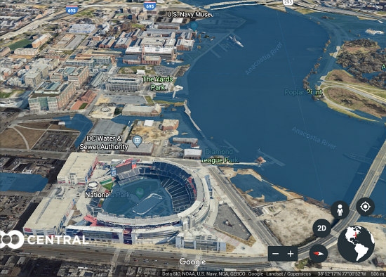
In Southeast, Poplar Point, Anacostia Park and the Joint Base at Anacostia-Bolling would largely be submerged, as well as the adjacent streets. On the opposite side of the Anacostia River, the field at Nationals Park would be flooded out.
In Southwest, sections of the new-and-not-yet-completed Wharf development as well as the Washington Channel would be waterlogged, as would portions of I-395 and I-695 and the surrounding neighborhoods, including a large swath of area north of P Street SW between First and 4th Streets. The new Audi Field may emerge unscathed.
Swelling along the Rock Creek tributary would be far less damaging due to the forested buffer along its edges, although the plaza at Washington Harbour and the buildings between Georgetown Waterfront Park and the C & O Canal may be severely impacted. Similarly, while RFK Stadium would be flooded, Kenilworth Aquatic Gardens and other patches of forest heading north up the Anacostia River offer protection to most of the residents of Northeast. Most of Southeast east of I-295 and the majority of the city north of H Street would remain intact.
For a closer look at how the city would handle rising sea levels, access to the Google Earth plug-in can be found here.
See other articles related to: flooding, flooding in dc, floodplain
This article originally published at https://dc.urbanturf.com/articles/blog/underwater-innings-new-software-shows-where-rising-sea-levels-would-impact-/13424.


UrbanTurf Listings showcases the DC metro area's best properties available for sale.
Most Popular... This Week • Last 30 Days • Ever

DC's homebuyer assistance programs can be a bit complex. This edition of First-Timer ... read »
When it comes to financing a home purchase, a 30-year mortgage is one of the most com... read »
Pocket listings are growing in popularity in the low-inventory market in the DC regio... read »

Plans for the development at a prominent DC intersection began nearly eight years ago... read »
The eight-bedroom, 35,000 square-foot home in McLean originally hit the market in 202... read »


DC Real Estate Guides
Short guides to navigating the DC-area real estate market
We've collected all our helpful guides for buying, selling and renting in and around Washington, DC in one place. Start browsing below!
First-Timer Primers
Intro guides for first-time home buyers
Unique Spaces
Awesome and unusual real estate from across the DC Metro