 Greater Greater Washington's DC Metro-Circulator Map
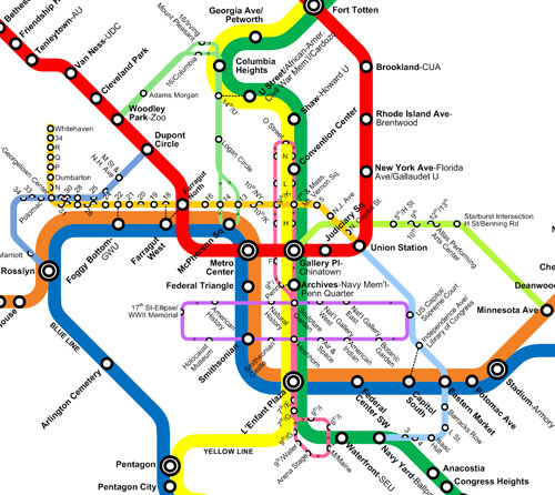
Greater Greater Washington has put together a very impressive map that combines the new DC Circulator routes with the existing DC Metro system. Check it out below, or for a larger version, click here.
Greater Greater Washington’s Metro-Circulator Map
The map includes both new Circulator routes: the first (in light green) which runs between Woodley Park and McPherson Square through Adams Morgan, Columbia Heights, U Street and Logan Circle, and the second (in light blue) which connects Union Station with Barracks Row and Nationals Park. Also included on the map are the H Street Shuttle and the Georgetown Metro Connection.
This article originally published at https://dc.urbanturf.com/articles/blog/greater_greater_washingtons_dc_metro-circulator_map/735.


UrbanTurf Listings showcases the DC metro area's best properties available for sale.

Most Popular... This Week • Last 30 Days • Ever

DC's homebuyer assistance programs can be a bit complex. This edition of First-Timer ... read »
When it comes to financing a home purchase, a 30-year mortgage is one of the most com... read »
Pocket listings are growing in popularity in the low-inventory market in the DC regio... read »

Margarite is a luxury 260-apartment property known for offering rich, high-end reside... read »
The owner of 700 Monroe Street NE filed a map amendment application with DC's Zoning ... read »


DC Real Estate Guides
Short guides to navigating the DC-area real estate market
We've collected all our helpful guides for buying, selling and renting in and around Washington, DC in one place. Start browsing below!
First-Timer Primers
Intro guides for first-time home buyers
Unique Spaces
Awesome and unusual real estate from across the DC Metro